OLD TOWNS BOOKS & MAPS
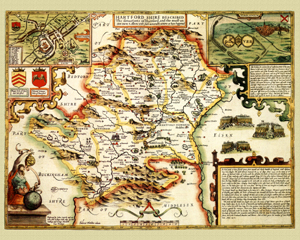
Old Maps of Hertfordshire
Essentials for Local Historians, Genealogists & Family Historians
MODERN MAPS
LOOKING FOR A DETAILED MODERN ORDNANCE SURVEY MAP OF A HERTFORDSHIRE TOWN? CLICK HERE
Hertfordshire in 1610
by John Speed
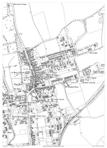
Hemel Hempstead in 1897
Size: 21.5 x 15.25 inches
Scale: 28 inches to the mile
Type: reproduction, flat sheet
CLICK MAP TO ENLARGE
PRICE: £7.99
Showing the area from beyond Cherry Bounce in the north to the junction of Crescent Road with Westview Road in the south, and from Bury Corn Mill in the west to Hemel Hempstead Union Workhouse in the east.