|
|||
|
|||
|
|||
 |
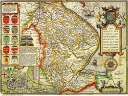
Printed area : approx. 50 x 38cm |
||
 |
Printed area : approx. 50 x 38cm Price : £15.00 + P&P BUY A PRINT OR DOWNLOAD NOW ... |
||
 |
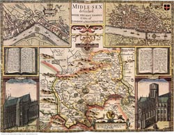
Printed area : approx. 50 x 38cm Price : £15.00 + P&P BUY A PRINT OR DOWNLOAD NOW ... |
||
 |
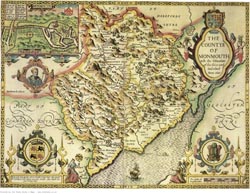
Printed area : approx. 50 x 38cm Price : £15.00 + P&P BUY A PRINT OR DOWNLOAD NOW ... |
||
 |
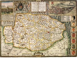
Printed area : approx. 50 x 38cm Price : £15.00 + P&P BUY A PRINT OR DOWNLOAD NOW ... |
||
 |
Printed area : approx. 50 x 38cm Price : £15.00 + P&P BUY A PRINT OR DOWNLOAD NOW ... |
||
 |
Printed area : approx. 50 x 38cm Price : £15.00 + P&P BUY A PRINT OR DOWNLOAD NOW ... |
||
 |
Printed area : approx. 50 x 38cm Price : £15.00 + P&P BUY A PRINT OR DOWNLOAD NOW ... |
||
 |
Printed area : approx. 50 x 38cm Price : £15.00 + P&P BUY A PRINT OR DOWNLOAD NOW ... |
||
 |
Printed area : approx. 50 x 38cm Price : £15.00 + P&P BUY A PRINT OR DOWNLOAD NOW ... |
||
 |
Printed area : approx. 50 x 38cm Price : £15.00 + P&P BUY A PRINT OR DOWNLOAD NOW ... |
||
 |
Printed area : approx. 50 x 38cm Price : £15.00 + P&P BUY A PRINT OR DOWNLOAD NOW ... |
||
 |
Printed area : approx. 50 x 38cm Price : £15.00 + P&P BUY A PRINT OR DOWNLOAD NOW ... |
||
 |
Printed area : approx. 50 x 38cm Price : £15.00 + P&P BUY A PRINT OR DOWNLOAD NOW ... |
||
 |
Printed area : approx. 50 x 38cm Price : £15.00 + P&P BUY A PRINT OR DOWNLOAD NOW ... |
||
 |
Printed area : approx. 50 x 38cm Price : £15.00 + P&P BUY A PRINT OR DOWNLOAD NOW ... |
||
 |
Printed area : approx. 50 x 38cm Price : £15.00 + P&P BUY A PRINT OR DOWNLOAD NOW ... |
||
 |
|
Printed area : approx. 50 x 38cm Price : £15.00 + P&P BUY A PRINT OR DOWNLOAD NOW ... |
|
 |
Printed area : approx. 50 x 38cm Price : £15.00 + P&P BUY A PRINT OR DOWNLOAD NOW ... |
||
 |
Printed area : approx. 50 x 38cm Price : £15.00 + P&P BUY A PRINT OR DOWNLOAD NOW ... |
||
 |
Printed area : approx. 50 x 38cm Price : £15.00 + P&P BUY A PRINT OR DOWNLOAD NOW ... |
||
 |
Printed area : approx. 50 x 38cm Price : £15.00 + P&P BUY A PRINT OR DOWNLOAD NOW ... |
||
 |
Printed area : approx. 50 x 38cm Price : £15.00 + P&P BUY A PRINT OR DOWNLOAD NOW ... |
||
 |
Printed area : approx. 50 x 38cm Price : £15.00 + P&P BUY A PRINT OR DOWNLOAD NOW ... |
||
 |
Printed area : approx. 50 x 38cm Price : £15.00 + P&P BUY A PRINT OR DOWNLOAD NOW ... |
||
 |
Printed area : approx. 50 x 38cm Price : £15.00 + P&P BUY A PRINT OR DOWNLOAD NOW ... |
||
 |
Printed area : approx. 50 x 38cm Price : £15.00 + P&P BUY A PRINT OR DOWNLOAD NOW ... |
||
 |
Printed area : approx. 50 x 38cm Price : £15.00 + P&P BUY A PRINT OR DOWNLOAD NOW ... |
||
 |
Printed area : approx. 50 x 38cm Price : £15.00 + P&P BUY A PRINT OR DOWNLOAD NOW ... |
||
 |
Printed area : approx. 50 x 38cm Price : £15.00 + P&P BUY A PRINT OR DOWNLOAD NOW ... |
||
 |
Printed area : approx. 50 x 38cm Price : £15.00 + P&P BUY A PRINT OR DOWNLOAD NOW ... |
||
 |
Printed area : approx. 50 x 38cm Price : £15.00 + P&P BUY A PRINT OR DOWNLOAD NOW ... |
||
 |
Printed area : approx. 50 x 38cm Price : £15.00 + P&P BUY A PRINT OR DOWNLOAD NOW ... |
||
 |
Printed area : approx. 50 x 38cm Price : £15.00 + P&P BUY A PRINT OR DOWNLOAD NOW ... |
||
 |
Printed area : approx. 50 x 38cm Price : £15.00 + P&P BUY A PRINT OR DOWNLOAD NOW ... |
||
 |
Printed area : approx. 50 x 38cm Price : £15.00 + P&P BUY A PRINT OR DOWNLOAD NOW ... |
||
 |
Printed area : approx. 50 x 38cm Price : £15.00 + P&P BUY A PRINT OR DOWNLOAD NOW ... |
||
 |
Printed area : approx. 50 x 38cm Price : £15.00 + P&P BUY A PRINT OR DOWNLOAD NOW ... |
||
 |
Printed area : approx. 50 x 38cm Price : £15.00 + P&P BUY A PRINT OR DOWNLOAD NOW ... |
||
 |
Printed area : approx. 50 x 38cm Price : £15.00 + P&P BUY A PRINT OR DOWNLOAD NOW ... |
||
 |
Printed area : approx. 50 x 38cm Price : £15.00 + P&P BUY A PRINT OR DOWNLOAD NOW ... |
||
 |
|
Printed area : approx. 50 x 38cm Price : £15.00 + P&P BUY A PRINT OR DOWNLOAD NOW ... |
|
 |
Printed area : approx. 50 x 38cm Price : £15.00 + P&P BUY A PRINT OR DOWNLOAD NOW ... |
||
 |
Printed area : approx. 50 x 38cm Price : £15.00 + P&P BUY A PRINT OR DOWNLOAD NOW ... |
||
|
|||
 |
Printed area : approx. 50 x 38cm Price : £15.00 + P&P BUY A PRINT OR DOWNLOAD NOW ... |
||
 |
Printed area : approx. 50 x 38cm Price : £15.00 + P&P BUY A PRINT OR DOWNLOAD NOW ... |
||
 |
Printed area : approx. 50 x 38cm Price : £15.00 + P&P BUY A PRINT OR DOWNLOAD NOW ... |
||
 |
Printed area : approx. 50 x 38cm Price : £15.00 + P&P BUY A PRINT OR DOWNLOAD NOW ... |
||
 |
Printed area : approx. 50 x 38cm Price : £15.00 + P&P BUY A PRINT OR DOWNLOAD NOW ... |
||
|
|||
 |
|
Printed area : approx. 50 x 38cm Price : £15.00 + P&P BUY A PRINT OR DOWNLOAD NOW ... |
|
 |
Printed area : approx. 50 x 38cm Price : £15.00 + P&P BUY A PRINT OR DOWNLOAD NOW ... |
||
 |
Printed area : approx. 50 x 38cm Price : £15.00 + P&P BUY A PRINT OR DOWNLOAD NOW ... |
||
 |
Printed area : approx. 50 x 38cm Price : £15.00 + P&P BUY A PRINT OR DOWNLOAD NOW ... |
||
 |
Printed area : approx. 50 x 38cm Price : £15.00 + P&P BUY A PRINT OR DOWNLOAD NOW ... |
||
 |
Printed area : approx. 50 x 38cm Price : £15.00 + P&P BUY A PRINT OR DOWNLOAD NOW ... |
||
 |
Printed area : approx. 50 x 38cm Price : £15.00 + P&P BUY A PRINT OR DOWNLOAD NOW ... |
||
 |
Printed area : approx. 50 x 38cm Price : £15.00 + P&P BUY A PRINT OR DOWNLOAD NOW ... |
||
 |
Printed area : approx. 50 x 38cm Price : £15.00 + P&P BUY A PRINT OR DOWNLOAD NOW ... |
||
 |
Printed area : approx. 50 x 38cm Price : £15.00 + P&P BUY A PRINT OR DOWNLOAD NOW ... |
||
 |
Printed area : approx. 50 x 38cm Price : £15.00 + P&P BUY A PRINT OR DOWNLOAD NOW ... |
||
 |
Printed area : approx. 50 x 38cm Price : £15.00 + P&P BUY A PRINT OR DOWNLOAD NOW ... |
||