OLD TOWNS BOOKS & MAPS
Old Maps of Cornwall
Essentials for Local Historians, Genealogists & Family Historians
There are dozens of great Cornwall maps to download at our new website:
www.oldtowns-downloads.co.uk
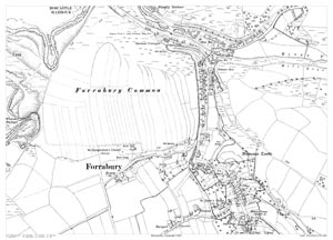
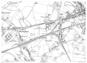
Scale: 28 inches to the mile
Size: 21.5 x 15.25 inches
CLICK MAP TO ENLARGE
Showing the area from Penally Terrace in the north to the Napoleon Inn in the south, and from Western Blackapit in the west to the Mill Leat in the east.
A large, brand new modern reprint
A FLAT-SHEET MAP (not folded)
SENT NEXT WORKING DAY
ROLLED IN A CARDBOARD TUBE
Full size 300dpi PDF format.
Instant secure download at purchase
View in Adobe Reader or similar software.
Zoom in for amazing detail.

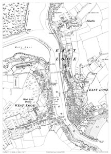
Scale: 28 inches to the mile
Size: 21.5 x 15.25 inches
CLICK MAP TO ENLARGEShowing the area from The Quarry in the north to the Pier in the south.
A large, brand new modern reprint
A FLAT-SHEET MAP (not folded)
SENT NEXT WORKING DAY
ROLLED IN A CARDBOARD TUBE
Full size 300dpi PDF format.
Instant secure download at purchase
View in Adobe Reader or similar software.
Zoom in for amazing detail.
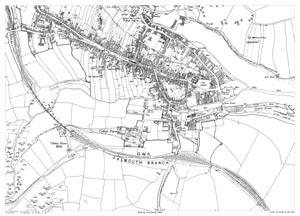
Penryn in 1906
Scale: 28 inches to the mile
Size: 21.5 x 15.25 inches
CLICK MAP TO ENLARGEShowing the area from the Iron Foundry in the north to beyond the railway in the south, and from railway viaduct in the west to the Granite Works in the east.
A large, brand new modern reprint
A FLAT-SHEET MAP (not folded)
SENT NEXT WORKING DAY
ROLLED IN A CARDBOARD TUBE
Full size 300dpi PDF format.
Instant secure download at purchase
View in Adobe Reader or similar software.
Zoom in for amazing detail.
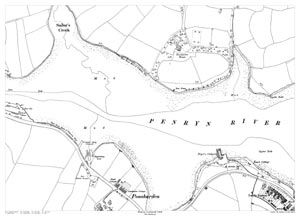
Scale: 28 inches to the mile
Size: 21.5 x 15.25 inches
CLICK MAP TO ENLARGE
A large, brand new modern reprint
A FLAT-SHEET MAP (not folded)
SENT NEXT WORKING DAY
ROLLED IN A CARDBOARD TUBE
Full size 300dpi PDF format.
Instant secure download at purchase
View in Adobe Reader or similar software.
Zoom in for amazing detail.
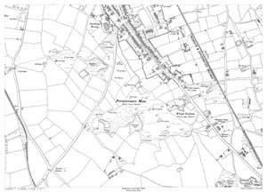
Scale: 28 inches to the mile
Size: 21.5 x 15.25 inches
CLICK MAP TO ENLARGEShowing the area from Pencoose in the north to Helston Road in the south, and from Westend Terrace in the west to Gorrangorras in the east.
A large, brand new modern reprint
A FLAT-SHEET MAP (not folded)
SENT NEXT WORKING DAY
ROLLED IN A CARDBOARD TUBE
Full size 300dpi PDF format.
Instant secure download at purchase
View in Adobe Reader or similar software.
Zoom in for amazing detail.
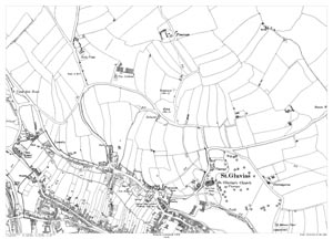
Scale: 28 inches to the mile
Size: 21.5 x 15.25 inches
CLICK MAP TO ENLARGEShowing the area from the Trefusis Arma in the north to beyond Perseverance Mine in the south.
A large, brand new modern reprint
A FLAT-SHEET MAP (not folded)
SENT NEXT WORKING DAY
ROLLED IN A CARDBOARD TUBE
Full size 300dpi PDF format.
Instant secure download at purchase
View in Adobe Reader or similar software.
Zoom in for amazing detail.
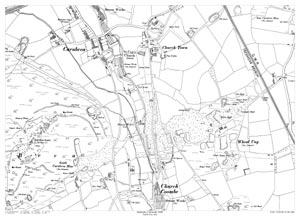
Scale: 28 inches to the mile
Size: 21.5 x 15.25 inches
CLICK MAP TO ENLARGEShowing the area from Church Town rectory in the north, to Church Coombe in the south, and from Giant's Well in the west to Wheal Uny in the east.
A large, brand new modern reprint
A FLAT-SHEET MAP (not folded)
SENT NEXT WORKING DAY
ROLLED IN A CARDBOARD TUBE
Full size 300dpi PDF format.
Instant secure download at purchase
View in Adobe Reader or similar software.
Zoom in for amazing detail.
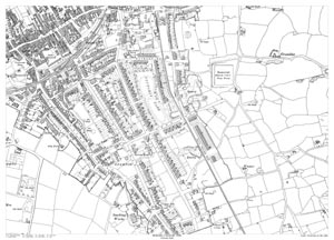
Redruth in 1906 - Victoria Park area
Scale: 28 inches to the mile
Size: 21.5 x 15.25 inches
CLICK MAP TO ENLARGEShowing the area from Bexley Street in the north to Osborne Road in the south, and from Green Lane in the west to Love Lane in the east.
A large, brand new modern reprint
A FLAT-SHEET MAP (not folded)
SENT NEXT WORKING DAY
ROLLED IN A CARDBOARD TUBE
Full size 300dpi PDF format.
Instant secure download at purchase
View in Adobe Reader or similar software.
Zoom in for amazing detail.
Redruth in 1906 - West End area
Scale: 28 inches to the mile
Size: 21.5 x 15.25 inches
CLICK MAP TO ENLARGEShowing the area from Penventon in the north to Church Lane in the south, and from Redruth Union Workhouse in the west to Trewirgie Road in the east.
A large, brand new modern reprint
A FLAT-SHEET MAP (not folded)
SENT NEXT WORKING DAY
ROLLED IN A CARDBOARD TUBE
Full size 300dpi PDF format.
Instant secure download at purchase
View in Adobe Reader or similar software.
Zoom in for amazing detail.
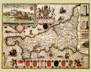
Cornwall in 1610
by John Speed
Size: 16 x 20 inches
GO TO THE JOHN SPEED PAGE