OLD TOWNS BOOKS & MAPS
Old Maps of Middlesex
Essentials for Local Historians, Genealogists & Family Historians
ORDNANCE SURVEY MAPS OF MIDDLESEX
The collection of seventy seven 1:10,560 scale maps (6" to the mile) is now online at our new website:
Direct link to the Middlesex page:
http://www.oldtowns-maps.co.uk/collections/middlesex-os-6
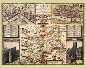
Middlesex in 1610
by John Speed
Size: 16 x 20 inches
GO TO THE JOHN SPEED PAGE