OLD TOWNS BOOKS & MAPS
Old Maps of Cumberland
Essentials for Local Historians, Genealogists & Family Historians
MODERN MAPS
LOOKING FOR A DETAILED MODERN ORDNANCE SURVEY MAP OF A CUMBRIAN TOWN? CLICK HERE
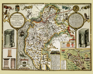
Cumberland in 1610
by John Speed
Size: 16 x 20 inches
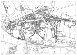
GO TO THE JOHN SPEED PAGECockermouth in 1900
Size: 21.5 x 15.5 inches
Scale: 28 inches to the mile
CLICK MAP TO ENLARGE
Showing the area from the Castle in the north to the Harris Park in the south, and from Derwent Bridge in the west to Bowling Green Hotel in the east.
A large, brand new modern reprint
A FLAT-SHEET MAP (not folded)
SENT NEXT WORKING DAY
ROLLED IN A CARDBOARD TUBE
Full size 300dpi PDF format.
Instant secure download at purchase
View in Adobe Reader or similar software.
Zoom in for amazing detail. .