OLD TOWNS BOOKS & MAPS
Old Maps of Cambridgeshire
Essentials for Local Historians, Genealogists & Family Historians
MODERN MAPS
LOOKING FOR A DETAILED ORDNANCE SURVEY MAP OF A CAMBRIDGESHIRE TOWN? CLICK HERE
Size: 21.5 x 15.5 inches
Scale: 28 inches to the mile
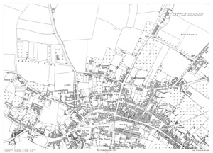
CLICK MAP TO ENLARGEShowing the area from Little London in the north to Holy Trinity Cathedral in the south, and from Mills Lane in the west to Brays Lane in the east.
A large, brand new modern reprint
A FLAT-SHEET MAP (not folded)
SENT NEXT WORKING DAY
ROLLED IN A CARDBOARD TUBE
Full size 300dpi PDF format.
Instant secure download at purchase
View in Adobe Reader or similar software.
Zoom in for amazing detail.

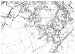
Ely (south) 1901
Size: 21.5 x 15.5 inches
Scale: 28 inches to the mile
CLICK MAP TO ENLARGEShowing the area from The Palace in the north to the Railway Station in the south, and from Smockmill Alley in the west to beyond The Quay in the east.
A large, brand new modern reprint
A FLAT-SHEET MAP (not folded)
SENT NEXT WORKING DAY
ROLLED IN A CARDBOARD TUBE
Full size 300dpi PDF format.
Instant secure download at purchase
View in Adobe Reader or similar software.
Zoom in for amazing detail.
Size: 21.5 x 14.25 inches
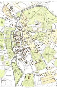
CLICK MAP TO ENLARGEA modern print showing in detail the area from County Gaol in the north, to Bateman Street in the south, and from Ridley Hall in the west to Gonville Place in the east.
A clear and easily read map; all roads are named, as are all local facilities, public buildings and institutions, for instance - churches, schools, hospitals, railway stations & lines, etc
A large, brand new modern reprint
A FLAT-SHEET MAP (not folded)
SENT NEXT WORKING DAY
ROLLED IN A CARDBOARD TUBE
Full size 300dpi PDF format.
Instant secure download at purchase
View in Adobe Reader or similar software.
Zoom in for amazing detail.
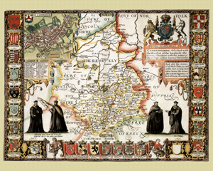
Cambridgeshire in 1610
by John Speed
Size: 16 x 20 inches
GO TO THE JOHN SPEED PAGE