OLD TOWNS BOOKS & MAPS
Old Maps of Bedfordshire
Essentials for Local Historians, Genealogists & Family Historians
MODERN MAPS
LOOKING FOR A DETAILED MODERN ORDNANCE SURVEY MAP OF A BEDFORDSHIRE TOWN? CLICK HERE
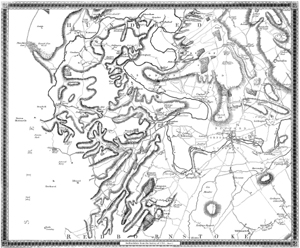
Sheet 1 Dunstaple area
ORIGINAL SCALE: 2" to the mile
PRINTED AREA: 20 x 16 inches
Showing Leighton Heath, Leighton Buzzard, Hockliffe, Chalgrave, Sundon, Upper Sundon, Houghton Regis, Dunstaple, Tillsworth, Stanbridge, Billington, Eaton Bray, Totternhoe, Kensworth, Caddington, Market Street, Whipsnade, etc...
A large, brand new modern reprint
A FLAT-SHEET MAP (not folded)
SENT NEXT WORKING DAY
ROLLED IN A CARDBOARD TUBE
Full size 300dpi PDF format.
Instant secure download at purchase
View in Adobe Reader or similar software.
Zoom in for amazing detail.

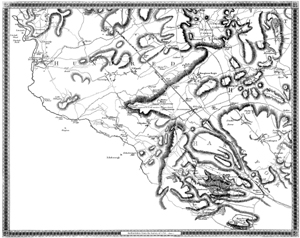
Sheet 3 Millbrook Warren area
ORIGINAL SCALE: 2" to the mile
PRINTED AREA: 20 x 16 inches
Showing (spelling as per map): Cranfield, Marston, Houghton Conquest, Hawnes, Maulden, Millbrook, Lidlington, Hullcott, Salford, Asple Guise, Husborn Crawley, Ridgemont, Stepingley, Flitwick, Flitton, Pulloxhill, Silsoe, Barton, Westoning, Harlington, Tingrith, Eversholt, Millton Bryam, Woburn, Potsgrave, Battlesdon, Tuddington, Stretley, etc...
A large, brand new modern reprint
A FLAT-SHEET MAP (not folded)
SENT NEXT WORKING DAY
ROLLED IN A CARDBOARD TUBE
Full size 300dpi PDF format.
Instant secure download at purchase
View in Adobe Reader or similar software.
Zoom in for amazing detail.
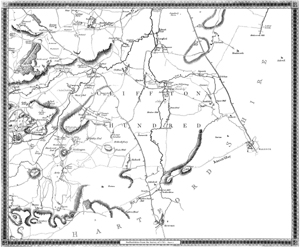
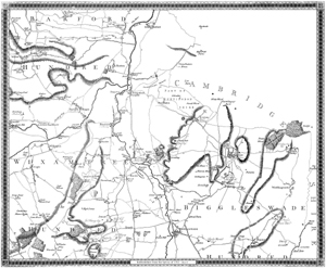
Sheet 4 Shefford area
ORIGINAL SCALE: 2" to the mile
PRINTED AREA: 20 x 16 inches
Showing (spelling as per map): Southill, Langford, edworth, Hinksworth, Astwick, Stotfold, Arlesey, Henlow, Cliffton, Shefford, Campton, Chicksand Abbey, Clophill, Over Gravenhurst, Lower Gravenhurst, Meppershall, Shitlington, Stondon, Hollwell, Ickleford, Higham Gobion, Hexton, etc...
A large, brand new modern reprint
A FLAT-SHEET MAP (not folded)
SENT NEXT WORKING DAY
ROLLED IN A CARDBOARD TUBE
Full size 300dpi PDF format.
Instant secure download at purchase
View in Adobe Reader or similar software.
Zoom in for amazing detail.
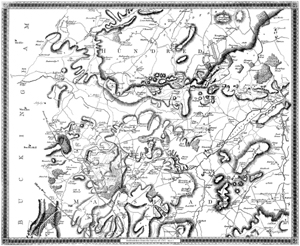
Sheet 5 Bedford area
ORIGINAL SCALE: 2" to the mile
PRINTED AREA: 20 x 16 inches
Showing (spelling as per map): Harrold, Odell, Chillington, Charlton, Felmersham, Pavingham, Bletsoe, Millton Ernys, Ravensden, Clapham, Bromham, Oakley, Steventon, Turvey, Stagsden or Stachden, Biddenham, Bedford, Goldington, Cardington, Elvestow, Kempston, Wootton, Willshamstead, etc...
A large, brand new modern reprint
A FLAT-SHEET MAP (not folded)
SENT NEXT WORKING DAY
ROLLED IN A CARDBOARD TUBE
Full size 300dpi PDF format.
Instant secure download at purchase
View in Adobe Reader or similar software.
Zoom in for amazing detail.
Sheet 6 Sandy area
ORIGINAL SCALE: 2" to the mile
PRINTED AREA: 20 x 16 inches
Showing (spelling as per map): Wildon, Roxton, Little Barford, Everton, Tempsford, Blunham, Barford Magna, Willington, Cople, Sandy, Potton, Sutton, Cockain Hatley, Wrestlingworth, Eyworth, Dunton, Biggleswade, Northill, Old Warden, etc...
A large, brand new modern reprint
A FLAT-SHEET MAP (not folded)
SENT NEXT WORKING DAY
ROLLED IN A CARDBOARD TUBE
Full size 300dpi PDF format.
Instant secure download at purchase
View in Adobe Reader or similar software.
Zoom in for amazing detail.
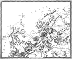
Sheet 7 Knotting area
ORIGINAL SCALE: 2" to the mile
PRINTED AREA: 20 x 16 inches
Showing (spelling as per map): Tillbrook, Swinshead, Shelton, Melchburne, Yeilden, Knotting, Riseley, Keysoe, Pertenhall, Sharnbrook, Souldrop, Thurleigh, Bolnhurst, etc...
A large, brand new modern reprint
A FLAT-SHEET MAP (not folded)
SENT NEXT WORKING DAY
ROLLED IN A CARDBOARD TUBE
Full size 300dpi PDF format.
Instant secure download at purchase
View in Adobe Reader or similar software.
Zoom in for amazing detail.
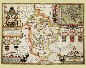
Bedfordshire in 1610
by John Speed
Size: 16 x 20 inches
GO TO THE JOHN SPEED PAGE